NanaimoMap Overview Guide
NanaimoMap is a web based tool to allow you to explore the City of Nanaimo's geographic data. Panning around the map, zooming in and out, and clicking on features allows you to learn more about them.
As you zoom in on the map, additional features may be displayed. You have the ability to control what layers you are interested in by turning them on or off in the layer list, or by changing the map theme. NanaimoMap includes search capabilities to find information by address, folio, parcel identifier, street name or park name.
This overview guide is designed to provide an overview of some of the common tools and features available in NanaimoMap. To learn more about specific functionality based on the device you are using, click on the appropriate link below.
NanaimoMap User Guide Desktop or Tablet
NanaimoMap User Guide Mobile
Navigation
Moving Around the Map
You can move around the map by holding your left mouse button down and dragging the mouse to move the map. If you are using a touch screen device simply move your finger across the screen to pan around.
Zooming In/Out
You can zoom in and out using your mouse wheel, by pinching to zoom with touch screen devices, or using the icons located in upper left corner of the map area.

View Information About Map Features
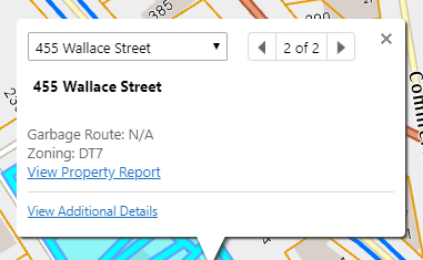
To learn more about a feature, left click the feature with your mouse, or tap the screen on touch screen devices. A map tip will open displaying summary information on the features selected. If there is more than one feature, arrows will appear on the map tip, allowing you to scroll through a map tip for each feature. Click on the "View Additional Details" link to view more information about it.
Layer Selection
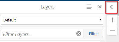
The layer list is displayed by default on desktop or tablet devices when the map first loads. If closed or using a mobile device, it can be opened by selecting "Change visible map layers" under the "I Want To" menu. To maximize space on the map, the layer list can be collapsed by clicking the arrow at the top right corner of the layer list. To expand the layer list, click the arrow again.
Turning Layers On/Off
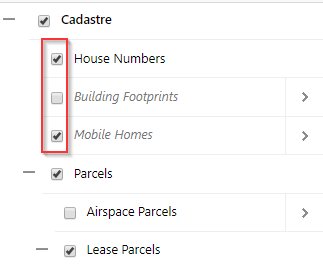
Turn a layer on or off by checking or unchecking the checkbox to the left of the layer name. Expand a folder by clicking the + icon to the left of the folder name. You can collapse a folder by clicking the - icon. To turn on layers within a folder, the folder must be check as well. Most layers are only visible at certain zoom ranges. If you have turned on a layer but do not see it, try zooming in.
Changing Layer Themes
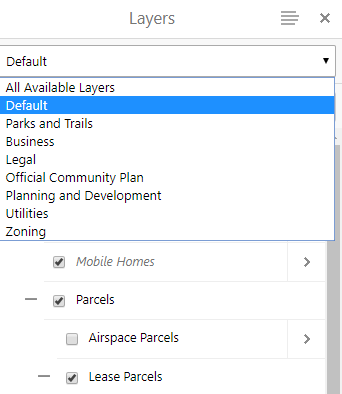
Layers are organized by themes. To change which layers are displayed you can change the map theme by selecting one from the drop down list under the Layers title.
View Aerial Imagery
If viewing NanaimoMap on a desktop PC or a tablet you can view historical imagery in the map. To view aerial imagery, select it from the Basemap Picker located in the bottom left hand corner of the map window. You have the option to choose from "Basemap", "2018 5cm" or "All Aerials".

Selecting "All Aerials" allows you to view aerial imagery from 1996-Current using a convenient slider.

If using a mobile device you can toggle on/off the most recent aerial imagery from the "I Want To" menu.
Map Legend
To view the map legend, click the menu icon in the top right corner of the layer list and click on "Show Legend", or the "View the Legend" button under the "I Want To" menu. This will display a legend of all the layers that are currently turned on in the layer list and visible at your current map scale.
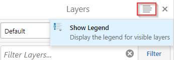
To show the layer list again, click the menu icon and choose "Show Layer List" or select "Change visible map layers" under the "I Want To" menu.

Tools
The toolbar contains series of tools, organized into tool tabs based on the tasks they perform. The toolbar is collapsed by default. To expand the toolbar, click the tools icon in the top right corner of the map window.

The tools that are available depend on the device being used to view NanaimoMap. Refer to the NanaimoMap User Guide, for descriptions of all the tools available based on the device being used.
Search
There are two options to search for features on the map. The global search bar located at the top right of the map returns a list of features with attributes that match the search text.
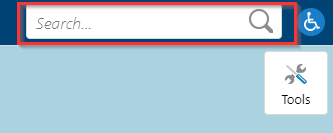
For better search results use the dedicated search tools located on the 'Find Data' toolbar tab for desktop and tablet devices, or located under the 'I Want To' button on mobile devices.

Please note: For Address, Street or Park search you can enter a partial word, or the entire word, but you may not use abbreviated words. After entering a few letters, the search tool will provide a list of matched values to choose from. Please select the value from the drop down list for the best results. The searches are not case sensitive. For Address search a street name value is required, house number and unit are optional.
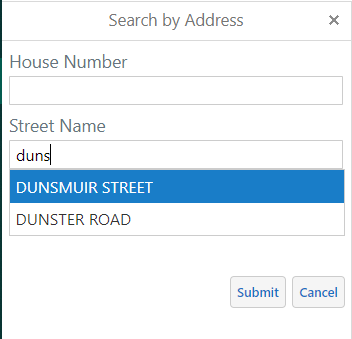
Folio search does not accept partial values to match, and requires the decimal to be entered.
PID search does not accept partial values to match.
To use one of the configured print templates to print a map, select "Print" from the Home tab or if using mobile, the "I Want To" menu. The Print Map panel will open, with choices for layout, resolution, map scale, map title and notes. A print preview will be displayed in the map window to show the area that will be printed for your selected scale and page size. When you are happy with your selections, click "Print". After a few moments a link will appear that opens up the pdf file.
Export
The
export tool allows you to save the current map image on your screen as an image
file. To export a map image, select "Export" from the Home tab or if using mobile, the "I Want To" menu. Select the
appropriate image format. Click "View Image" to open the image in another
tab in your browser. You can then right click on the image and choose Save
picture as... to save the file to your computer or save it to your mobile device.
Measure
Measuring tools are located in the toolbar, allowing you to measure area or distance in the desired units you choose. Use the "Clear" button to remove all markups, or the "Erase" button to choose which markup to remove.
Draw
Drawing markup tools are located in the desktop "Draw" toolbar, allowing you to create markups on the map. Once you select the drawing tool, the Styles and Snapping tools will become active. You can customize the colour and size of a markup by selecting the Styles tool. You can select which features to snap to by using the the Snapping tools. The "Edit Drawings" group contains tools to edit, erase or clear existing drawings. You can also export drawings to download as a shapefile.
Last updated: November 14, 2024
Give feedback on accessibility. Submit your feedback through our online accessibility feedback form. Help us understand barriers people face when accessing City services.
You can attach files to help explain the barrier you faced in the form, like: a video, voice recording or photos. If American Sign Language (ASL) is the best way for you to communicate, upload a video of yourself using ASL into the form.
Please include: what you were trying to access, where the barrier happened, what the barrier was and any recommendations you might have.
Help us improve our website
Important Information About Privacy
Information collected on this form is done so under the general authority of the Community Charter and Freedom of Information and Privacy Protection Act (FOIPPA), and is protected in accordance with FOIPPA. Personal information will only be used by authorized staff to fulfill the purpose for which it was originally collected, or for a use consistent with that purpose.
For further information regarding the collection, use, or disclosure of personal information, please contact the Legislative Services Office at 250-755-4405 or at foi@nanaimo.ca

